Source Laboratory
Source Laboratory
Source Laboratory is one of five laboratories that make up the Dariah.lab infrastructure. It is responsible for providing infrastructure, standards and methodology used in the initial stages of data processing, i.e., acquiring high-quality digital representations of diverse objects, describing, storing and sharing data. Data acquired in the Laboratory is a subject of research conducted in three areas of digital humanities which are essential for the DARIAH-PL project – geoarchaeology, cultural data and musicology.
Non-invasive Archeology
In the process of digitizing and documenting archaeological objects, it is important to be able to acquire data in a non-invasive manner. That means locating hidden underground archaeological structures and objects without lengthy and environmentally destructive excavations, and acquiring digital models of monuments for reconstruction, research or presentation.
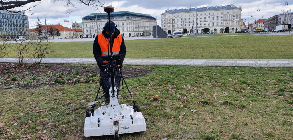
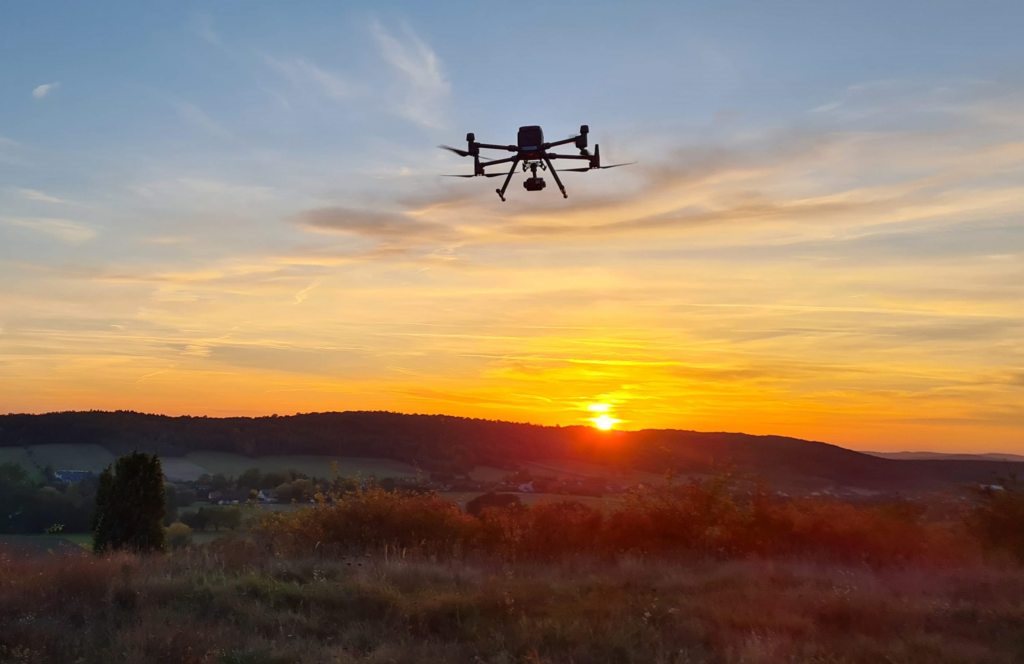
Source Laboratory will be equipped with GPRs (Ground Penetrating Radars), specialized drones, spectrometers, 3D scanners and specialized software for processing and analyzing collected data.. These devices can provide view of structures invisible to human eye and enable their digital documentation as well as perform digitization of cultural landscape objects. They make it possible not only to locate potential archaeological sites, but also to reconstruct structures beneath the earth’s surface and to generate digital models of monuments, both entire buildings and smaller objects.
Georadars
GPR can detect hidden underground structures. Its operation is based on the emission of an electromagnetic wave by a transmitting antenna. After being reflected or refracted at the boundary of two media differing in their dielectric constant, the wave returns and is recorded by a receiving antenna. This antenna records the strength of the returning signal and the time after which the signal returns. A scan of an area can be performed by sending a series of pulses and recording the returning signal. Shape of the detected object is then reconstructed by processing the collected data.
A lot of data can be obtained by recording, measuring and interpreting photos of an area or an object, i.e., by photogrammetry and remote sensing. With a series of photos, it is possible to reconstruct the shape of the photographed object, its size and location, or even to generate a 3D model. However, such models are not very accurate, so they are typically used to create large-scale maps of area whose photos were taken by drones.
Scanners, drones and spectrometers
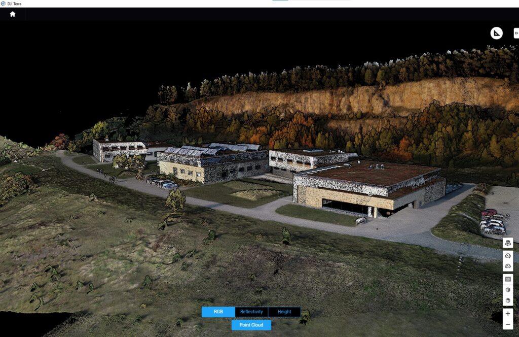
Generating a more accurate digital representation of an object in the form of a 3D model requires use of a 3D scanner. A laser scanner (Light Detection and Ranging, LIDAR) emits a beam of radiation aimed at the scanned object and measures the distance between the light source and the object. The results of the measurement are used to determine the spatial coordinates of a set of points, and the software determines their position in the coordinate system of the scanner (a moiré method based on the interference of geometric line systems). The coordinates thus obtained are saved as a digital point cloud.
Another group of devices used for 3D modelling are structured light scanners, which are better at capturing fine details than laser scanners. More importantly, they are used for scanning objects that could be damaged by laser light. This property is especially important when scanning antiquities such as paintings, manuscripts and old prints.
Regardless of the scanning technology, handheld scanners are used for smaller objects, allowing convenient “handheld” scanning. Larger objects, such as buildings or monuments, require stationary scanners. Usually laser technology is used when distance between the scanner and the objects to be scanned is large. Typically multiple scans are performed to acquire data from different perspectives and viewpoints. In addition to handheld and stationary scanners. The Laboratory will be equipped with scanners mounted on drones for collecting data from a bird’s-eye view and in hard-to-reach areas.
The above mentioned equipment and the accompanying software will enable digitization and documentation of buildings, monuments, human remains (skulls, bones), museum objects, scribal resources, and, with the help of drones, also archaeological sites such as fortified settlements, castles, cemeteries with precise location and precise distance measurements.
Not only can objects relevant to archaeological research be detected and identified in a non-invasive manner, but also it is possible to determine their chemical composition without taking and irreversibly destroying samples. This task can be performed with a spectrometer – a specialized device for the analysis of the elemental composition of substances based on the recorded spectrum, which will be available at the Laboratory. It is used to determine both the chemical composition and to measure the physical properties of matter. Different substances absorb, reflect or emit light in a way that depends on their chemical structure and environment. The operation of a spectrometer involves focusing electromagnetic energy from a light source onto a sample of the material under study. Depending on the configuration of the system, light is reflected from or transmitted through the sample, and then tested for the light intensity at various wavelengths that make up the tested beam.
State-of-the-Art Image and Sound Recording Techniques
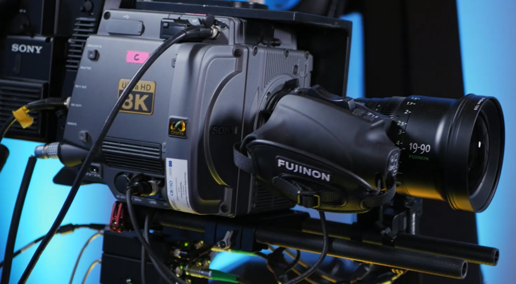
Source Laboratory will offer audio and audiovisual content recording equipment such as high-definition television and film cameras (4K and 8K) for recording images with resolutions close to that of a human eye. Recording of cultural and artistic events (theater performances, concerts), as well as ethnomusicological and ethnographic documentation (e.g., performances of folk groups, historical re-enactments) will be possible with the use of multiple cameras and with the possibility of simultaneous transmission through the computer network with a low latency. Along traditional video cameras the Laboratory will be equipped with devices for recording images in innovative technologies such as VR/360° video (omnidirectional cameras), plenoptics and stereoscopy.
360° and 3D Cameras
Cameras capable of recording 360° video are equipped with one or several lenses that record several video tracks simultaneously. A 360° camera with a single lens records a spherical image, which is then flattened so that it can be rotated. When several lenses are used, the images recorded by these lenses are very precisely combined into a single image spanning 360° in a process called “stitching.”
Photos taken with a plenoptic camera offer a whole new way of perceiving images. These images are not static and can modified by a user after they have been recorded, for example, by changing the focus, point of view or perceived depth of field. The changes are made by mathematical transformations of the signal recorded by the camera. This signal contains all the information needed to generate a three-dimensional representation of the recorded scene. This means that a plenoptic camera is in fact a 3D camera.
A three-dimensional representation can be obtained by taking a series of photos of a scene from different angles using a single camera or a multi-camera system. In the former case, an object is placed on a special platform that rotates the object by a preset angle for each picture. In this way one can obtain precise images of the entire rotation. A three-dimensional representation can also be produced by a camera equipped with an array of microlenses placed in front of the main camera sensor. In this case, each microlens captures a small image from a different angle. Individual images are formed by capturing light rays whose sources are located at different points in space. Then the distance between each object in the scene and the camera is calculated to determine its position and to develop a three-dimensional model of the recorded scene. Such a model enables subsequent presentation of the scene with the ability to view it in the so-called six-degrees-of-freedom (6DOF).
Immersive Sound
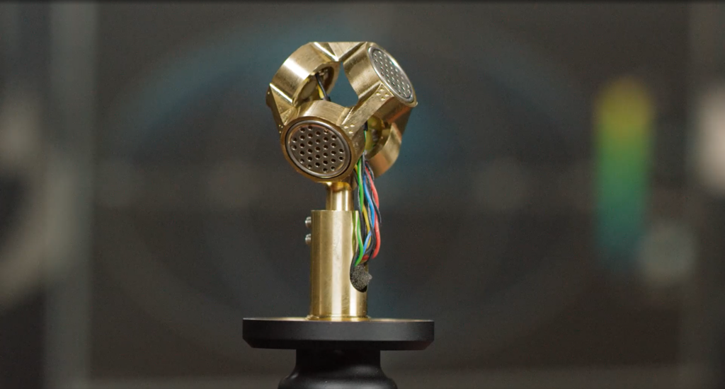
In addition to traditional microphones and digital sound recorders, the Laboratory will be equipped with multi-microphone and immersive sound systems. Spatial sound microphones (e.g., High Order Ambisonics, HOA), in contrast to multi-channel systems (stereo or surround sound), make it possible to build the so-called sound picture not only in the horizontal plane, but also in the vertical plane, which is important for research in fields such as musicology or ethnography. Immersive sound systems make it possible to combine recorded sound with immersive visualization installations and virtual and augmented reality techniques – combining images acquired from laser scanners or VR/360° cameras with ambisonic sound.
Beyond Recording
Source Laboratory will offer not only immersive video and sound recording services, but also their post-production, editing and presentation, which requires additional equipment such as a surround sound playback system consisting of a multi-element loudspeaker installation. The infrastructure for acquiring audiovisual content and the aforementioned speaker installation will be complemented by the Advanced Visualization Laboratory equipment that will include immersive LED walls, projectors for so-called mapping of buildings and other architectural elements, and multi-projector systems.
Mapping involves projecting an image from a high-brightness projector or projectors onto an architectural object. Once the visualization is prepared, the projected image must be adjusted to the structure of the planes on which it is to be displayed. It is done by mathematically recalculating and adjusting an image to a model of the building or terrain (known as an object map). Most often, this technique is used at festivals or multimedia shows to make the display of buildings more attractive but it can also be used in archaeology or architecture to show an earlier appearance of an object (its colors and details that no longer exist), e.g., castle ruins. Mapping equipment will be a part of the Advanced Visualization Laboratory.
The use of the above-mentioned innovative audio and image recording methods is of considerable importance for acquiring research data. Modern sound recording equipment makes it possible to document the manifestations of traditional music performance, to capture a given piece along with features not reflected in the score, such as permanent variation. Video documentation makes it possible not only to capture a broad performance context of the recorded situation (e.g., to show what the relationships are between the active performance participants) but also to document elements of performance technique that are important for ethnomusicological and instrumentological research, for example how the performer holds the instrument and how he plays it.
It is worth noting that a large part of Source Laboratory equipment will be mobile. Thus, It will be possible to perform recording in the field and transmit the signal over the Internet which is important given the nature of the content to be recorded (archaeological sites, outdoor events such as concerts or historical re-enactments).
Analog Resources Digitization
With the development of ICT, researchers are gaining access to modern methods for collecting, processing and analyzing data. The great wealth of cultural heritage however, has been accumulated over centuries in the analog form, i.e., manuscripts, printed documents or traditional photographs. Archives with a significant number of recordings in the form of magnetic tapes or vinyl records have also been created over the past several decades.
The analog form of these resources greatly limits the possibilities for their widespread sharing or analysis. Worse yet their condition is deteriorating over time. The solution in this situation is an extensive digitization of the existing analog collections, that is, conversion to digital form. How is done? In a nutshell, by using specialized scanners, digital cameras and equipment for sound recordings digitization, which will be available in the Sources Laboratory.
Digitization Equipment
Due to a large variety of objects that should be digitized, the Laboratory will be equipped with several different digitization systems designed for each category of objects to ensure the highest quality and efficiency of data acquisition. It is important to render the overall look or sound of the object being digitized accurately, without distortions, capturing all its characteristics and individual features.
The Source Laboratory equipment will include specialized scanners (up to A0+ format), high-resolution cameras and photo set lighting as well as picture scanning frames or rotating platforms for taking pictures of 3D objects. They will be complemented by cameras and camcorders that record images in infrared, which makes it possible to detect pigment defects or cracks in artworks that are invisible to human eye. This technique is particularly useful for the conservation of museum objects. In addition, specialized image processing software will allow combining images, post-production of the collected material and its subsequent sharing. The process of acquiring and processing images and scans will meet FADGI (Federal Agencies Digital Guidelines Initiative) standards, which are the de facto standard for museums and cultural heritage digitization projects.
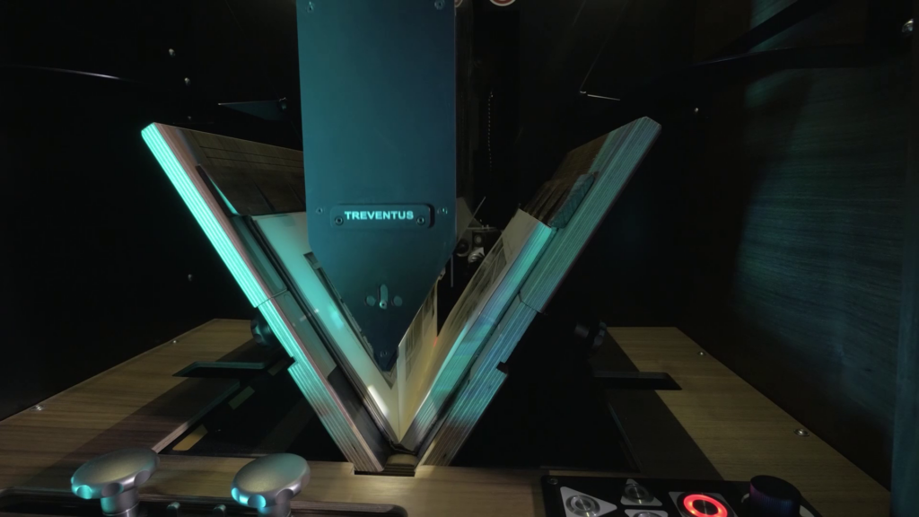
Digital scanning stations will be complemented by analog photography equipment. Although becoming increasingly less popular, it is still used not only in art but also for documentation of cultural monuments. The reflection of colors or the optical resolution often makes it possible for analog photos – especially large format ones – to capture what digital photography cannot. The analog photography stand will include medium and large format cameras, photographic darkroom equipment and exhibition elements. In addition, support will be provided for so called noble photography techniques (e.g., wet collodion, cyanotype), which are important not only for artists photographers, but also for studying the processes related to the history of photography.
It is worth mentioning at this point that DARIAH-PL is a project recognized as a so-called Local Time Machine Project due to its contribution to the use of modern technologies to support, protect, preserve, restore and promote European cultural heritage.
Data Storage and Sharing in Accordance with FAIR Principles
”Data should be as open as possible and as closed as necessary.”
Data acquired at the Source Lab and generated at this and other Dariah.lab laboratories as research data should be stored and shared according to the FAIR (Findable, Accessible, Interoperable, Reusable) principles. The Source Laboratory will provide a solution that implements these principles, including a service providing dedicated digital repositories in a cloud environment and an unambiguous data identification service.
Research in many cases focuses on specific data collections (e.g., women’s digital archives, numismatic databases, music datasets). Hence, there is a need to adapt repository to the type of data stored and the metadata describing it, as well as the needs of its users. Automated service for setting up a repository provided in the Source Laboratory, will free users from having to get into the technical details, allowing them to configure the repository or select one of the predefined systems via a browser.
Making data available in such a way that it can be referenced by external systems requires obtaining and sharing a globally unique identifier that provides a long-lasting and immutable reference to a specific resource. This is a necessary element for integrating data into international information flows. Existing identification services are not designed to handle specific data, such as spatial data. The popular DOI system is based on a business model in which large amounts of data can generate high costs. The ID attribution service offered at the Source Laboratory will be tailored to the specifics of research data and the needs of the scientific community.